History of Hāwea
From a significant mahinga kai and wāhanga for generations of Māori, to high-country pastoral runs, a productive farming settlement and recreational tourism destination for early Europeans, the Hāwea community was borne.
Māori & Early History
Lake Hāwea was visited seasonally by Māori - at first, Waitaha people, then Ngāti Mamoe and Ngāi Tahu communities - who established several mahinga kai (food gathering centres) around the shores of the lake. Food sources included Kauru (Cordyline), weka, fern root, eels, kea, pigeon, kaka, kiwi and kakapo. An important one of these mahinga kai was Manuhaea (the settlement at ‘The Neck’). As well as being a mahinga kai, Manuhaea was also a wāhanga (school of learning) where tohunga (learned people) were taught the history and whakapapa (genealogies) of their ancestors.
A raid in 1836 by Te Puoho, of Ngāti Tama, caused the Māori people to desert Manuhaea. Te Pūoho had fought continuously against tribal enemies from Taranaki southwards. Crossing the Cook Strait, Te Pūoho moved down the West Coast, where he was encouraged by Te Rauparaha in his bold plan to conquer the dominant Ngāi Tahu of the South Island. Te Pūoho and his war party of about 100 people, made their way across the Haast Pass in 1836, through Makarora and onto Lake Hāwea, raiding the seasonal settlements and causing the Ngāi Tahu to flee.
After Te Pūoho’s raid in 1836 the Māori settlements Lake Hāwea or the Upper Clutha area were deserted and by the time the first Europeans arrived as visitors, the area appeared vacant to the early visiting surveyors and settlers. Over the following years, the region was explored, surveyed and gradually converted into high pastoral runs. Gold was found in the surrounding rivers (mainly Cardrona River) and saw-milling became a supporting industry to the gold-mining settlements.
Subsequently, purchases of South Island land left a number of Ngāi Tahu people with insufficient land to support their families. Following two reports in 1887 and 1891, the Crown agreed to give land rights back to Ngāi Tahu and by 1905, 1,553 acres at Manuhaea was allocated to 57 people. Unfortunately, in 1909, before the block of land had been granted, the South Island Landless Natives Act (SILNA) was repealed.
In 1998, under the Ngāi Tahu Claims Settlement Act, the government acknowledged the Treaty of Waitangi principles had been breached and that the block was to be returned to Ngāi Tahu. Because it was now under pastoral lease, in 2010, a substitute block of similar value and area was vested in the descendants of the original owners. This was the reserve in Wānaka, known as the Sticky Forest, which had been developed into a popular mountain-bike area, along with three other one-hectare lots: one adjoining the camping ground on the south-western corner of the lake; another on the western side of the lake, and another at the mouth of Timaru Creek.
The Hāwea area was first surveyed by John Turnbull Thomson who was the Chief Surveyor of the Otago area. During 1856-1857, he explored large areas of the South Island and named a number of the mountains including Mt Grandview, Tititea/Mt Aspiring and Mt Pisa.
Hāwea Flat Settlement
Hāwea Flat was originally the main settlement in the area, built to serve the local farming community. Before bridges were built, the settlement at Hāwea Flat gave access to the punts across the Clutha River at Newcastle (now called Albert Town) via Newcastle Road, on Camp Hill Road and at Luggate.

‘The first despatch & delivery of mails’ - Hāwea Flat Post Office. Photo: Supplied by Otago Witness
Hāwea Flat was divided into ‘hundreds’ during the 19th century. ‘Hundreds’ referred to the size of land estimated to support one hundred people. Unlike the high country runs around and north of the lake (which were under pastoral lease), the hundreds were free-holded to their farmers. During these early farming days, Hāwea Flat primarily farmed grain, producing wheat for the Dunedin bakeries, barley for the Dunedin brewery and oats for the local horses.
Several of the roads in Hāwea Flat are named after the early European settlers, or their land. McLennan, Lachlan, Butterfield, Paterson, Loach and Kane Roads are named after early families and Partridge Road is named after the type of peas which grew in on the local farms. Camp Hill Road is the name of Bert Butterfield’s property.
The McLennan family were among the first of the very early settlers, building their house ‘Blairnhall’ – named after the place in Scotland where their third child had been born – on the Hāwea Back Road, which was the first link between the settlement and the lake. In 1878, their daughter, Flora Jane was the first European to be born at Hāwea Flat.
The McCarthy family were another of the very early families, with John McCarthy emigrating from Ireland in 1871. John and his wife Margaret built a stone house and barn in 1892. John was particularly interested in both education and development of the area and put pressure on the Ministry of Education to open a school. The McCarthy’s still reside on family land in Hāwea Flat today, and generations of the family have attended the school.
The McLennan family donated the iconic triangle of land between Kane, Camp Hill Road and St Ninian’s Way to the community around 1880. This significant piece of land became the centre for the Hāwea Flat community and remains so today. In 1882, the primary school was established here. The Post Office (now the venue for the local Hāwea playgroup) was also built on the McLennan family donated land, along with the St Ninian’s Presbyterian Church in 1938. The Hāwea Kindergarten was added beside the church in the early years of the 21st century and the Hāwea Community Hall on St Ninian’s Way.
The Urquharts moved to Hāwea Flat from Scotland and were the third family to build a home in the Flat. Generations later, their descendants are still farming in the area today.
In 1892, St Patrick’s Catholic Church was the first church built in the district land, located at St Patricks Way. The church was deconsecrated in about 1980, becoming a private dwelling and is still located in St Patricks Way.
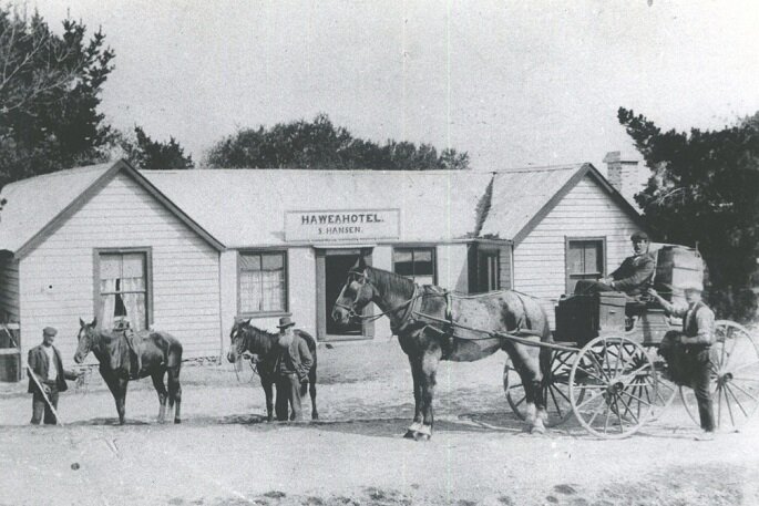
During the early days of the Hāwea Flat settlement, a hotel and a blacksmith was built by Robert Cayford, who also organised the first of the Hāwea races, at ‘Blairnhall’. Two additional hotels including ‘The Occidental’ were established in these early years, when it was the main centre for the district.
Windmill corner, where Kane Road takes a sharp turn at the northern entrance to the settlement, now contains a non-working model of the original windmill which pumped water to the local area.
Lake Hāwea Settlement
With Hāwea Flat as the main settlement in the area due to the farming suitable land, until the twentieth century, nobody lived permanently on the southern foreshore of Lake Hāwea.
The land was farmed by the Muir family, who lived and farmed in the area for several generations and the Capell family, who owned the land at the western end of the foreshore. Claude Capell bought approximately 160 hectares to build his accommodation and fishing guiding business, while farming the land to the south of the lodge, in the area now known as Timsfield. He named several streets in the developing village; Noema (for his son, otherwise known as Tim), Myra Street (for his daughter), Elizabeth Street (for his wife) and Flora Dora Parade (for his later housekeeper/companion). Peter Fraser Park, Skinner Crescent, Parry Crescent and Bodkin Street were all named after political figures. Claude donated the land on which Peter Fraser Park was developed.

‘Lakehouse’ - Claude Capell's Accommodation House. Photo: Hocken collection
In 1925, Claude opened his lodge ‘Lakehouse’, and bought a boat called the ‘Bellbird’. Visitors to Lakehouse (often from Dunedin) were taken on the lake to fish and sight-see. Claude’s business was later taken over by his son Tim and daughter-in-law Edna. After the war, in 1944, Tim and Edna began a local taxi service, later adding the school bus service.
Investigations for the dam began in 1952 and, until the Ministry of Works staff hostel was built, geologists, engineers and tradesmen stayed at Lakehouse. Claude Capell had initiated the water supply for Lakehouse and the growing township, piping two creeks over the Hāwea River to a tank he had installed on Myra Street. The Ministry of Works asked to use Claude’s system, eventually agreeing to upgrade the infrastructure.
In August 1957, the first car made it over the the Haast Pass, and Claude’s dream of a driveable road to Haast had been realised albeit very rough terrain. Finally, after the Hāwea dam gates had been opened in 1958, Tim and Edna retired in 1961. Claude Capell died when he was 93, in 1974.

Roads & Road Making between Hāwea - Wanaka (1934) Photo: Alexander Turnbull Library
The township gradually grew once Claude had subdivided his land, and although at first most of the dwellings were holiday homes, permanent residents began to settle there. The first of these were Keith and Brenda Taylor, who saw the need for more visitor accommodation and built the first motel unit on Capell Avenue in stages as money became available. Sheep from the Muir farm that grazed the foreshore land were known to invade the motel carport – a reminder that the place was still largely rural.
The Muir land along the foreshore was also eventually subdivided and sold for residential builds. At first, holiday homes were built, including the Gilkison family from Dunedin - the beach in front of their crib was named Scott’s Beach, after the family’s grandson. Permanent houses were built later, and by the late twentieth century the Lake Hāwea township had become occupied by many full-time residents, both retired people and families working in the district.

Hāwea Hotel (destroyed by fire). Photo: Alexandra District Historical Association
Petrol was first sold by Tim and Edna Capell, before the road went beyond Makarora, then sold their licence to Wattie Taylor who established his workshop and petrol station on Camphill Road to supply the Hāwea Flat community. When the dam village appeared at Timsfield, Bill Barnett built a petrol station on the corner of Domain and Cemetery Roads, then eventually shifted the business to State Highway 6, just south of the dam.
Wattie Taylor also built the store on Lakeview Terrace, and his family moved on several occasions between Hāwea Flat and the growing Lake Hāwea township. Eventually, the two Taylor sons, John and Graham, linked the two communities with John settling at the lake and Graham at the Flat, before he and his wife moved to Luggate.
Once the lake foreshore began to be settled permanently, some of the beaches were named after local residents or reflecting the reasons visitors came to them. At John Creek (named after Sam John, who farmed there during the nineteenth century), holiday homes were built on the triangle of land between the creek and the lake shore.
Interested in the history of Hāwea?
The Upper Clutha Historical Records Society was established in 1985 to collect and preserve records and images of the history of the Upper Clutha region and make them available to members of the public. The records are held in a special room in the Wanaka Library and a team of volunteers provides research assistance (appointments are necessary) to members of the public who may be looking for their family history or for persons searching for aspects of NZ history.
The above information is compiled from ‘A Pretty Good Place to Live: Lake Hāwea & Hāwea Flat’ by Barbara Chinn (Upper Clutha Historical Records Society).
Further Reading
A Pretty Good Place To Live: Lake Hāwea & Hāwea Flat
By Barbara Chinn (free book to download)
Timeline of Significant Events in Local History
Upper Clutha Historical Records Society website
128 Years on the Flat: A History of the Hāwea Flat School and Hāwea Flat
By Glenda Turnbull
Albert Town History
Albert Town Community Association website